
Day 3
We thought we’d get to Grasmere early and get to some of the walking shops. After all it was only 9 and a bit miles and we were cutting a mile of that out as Gillercombe, the B&B, was just down before Rosthwaite. The ‘official’ path technically goes up into Rosthwaite and then down the other side, but as we’d kind of done that the night before to go out for our dinner it was agreed that going across the bottom of the triangle to meet that path this morning was acceptable. Just as well because I was the last one to get out AGAIN, and the team were all downstairs patiently waiting. This time I had a camelbak issue so it was sort of an excuse. Suffice to say the water pipe is being ditched for regular bottles which was one of the reasons for the planned shop. I also had to ask Rachel, our landlady, for a spare spoon as I’d managed to lose the one I had. I couldn’t work out how I’d done it. She said, judging by the state of the room at that time, that she wasn’t surprised at all. Have to say though, she was a great host and made us feel right at home, if our homes were more chintzy. Her cooked breakfasts were superb.
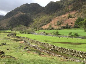
We had the wet weather gear on again as there was rain forecast for the day. It didn’t materialise and in fact we had a bit of sunshine in the morning which was quite lovely. Only problem was that the rains had already been, overnight and by the looks of it over the several days previous. Our little gentle saunter from Stonethwaite Bridge along the bridleway turned into a game of stepping stones in a newly formed stream! Even before we got to the foot of Lining Crag, our first major climb of the day, we had covered barely 2 miles in over 3 hours. The path had the odd dry patch here and there which was how you knew it was a path and not a waterway. The grass and moss on either side could be dry or could be a spongy bog waiting to suck the boot off your foot. Then there were the newly formed rivers running crossways at various points that created little puzzles for us. Where was the best place to cross? Which stones looked solid, which were slippy or wobbly? Was it possible to step all the way across or would we have to make a leap of faith. Hands up who has dry feet still?
 x
x
So the thing is, that this stretch of the walk and Day 2’s stretch were done by some of our group last year, at roughly the same time of year as a little practice and it was by their accounts a completely different experience. For Day 2 they had the same mirky drizzly walk around Ennerdale but then the sun came out for the rest of the day and there was no wind (ferocious or otherwise) and they sat on the tops in their t-shirts and had a little sunbathe. For their Day 3, their hard part started when they started stepping up the crag. Today, that bit wasn’t so much the issue as the dancing around the rivulets and although we could feel the ascent in our legs, it was hard looking up for all the looking down that was required. Plus there was wind, not quite so strong as yesterday but still pretty relentless. I think I did see the little flowers that Wainwright talks about in his book at the top of Lining Crag, called Starry Saxifrage or, as Julie misremembered, ‘Sexy Frangipane’ but I was too tired to take a picture. We did not try and do the Ridge walk that is possible at this point but dipped down into the Wythburn basin and up over Far Easedale from which the path to Grasmere was true but tediously long.
We got there just before 4pm. We’d managed the 8.2 miles in about 6 and a half arduous hours. But the Quaker run B&B had a wonderful drying room with stacks of newspapers and we managed to stuff our shoes and make a quick change. Then Julie and I did a mad dash about so that I could get my water bottles and a new woolly hat (I’d mislaid mine after day 1) and she could get some more inner socks (which she found) and long sleeved thin tops (which she didn’t). I was able though to lend her one of my Primark specials until Simon (her husband) arrived again at the weekend. So it all ended well in the end.
Day 4
There are a couple of routes to Grisedale Tarn. We thought we’d take the easier one as we needed a breather after all the challenges we’d had in the previous days. The gentler path is Tongue Gill on the south side. We were two thirds of the way up after having puffed and panted at the rather steep stepless incline when Sally (master navigator for the day) consulted the maps with a furrowed brow. ‘So I think we took a wrong turning at the bridge at the bottom.’ Where we should have gone straight we went left and essentially up Little Tongue side of the Great Tongue (I’m only describing this so I can write down these awesome names). Which happened to be the harder route. There was a murmur of consternation and then Julie pointed out that she felt so much better knowing that she found the hard path ‘hard’ and not the easy path. That made complete sense to us at the time and we all nodded in agreement and felt better.
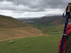
A tarn is like a lake that is in the mountains, like a gigantic basin really. This one looked very calm and picturesque, until the winds whipped up at the point when we wanted to sit and eat something.


We wended our way around and descended down without too much mishap. It was still water logged but we were used to it by now and we weren’t far from Patterdale. We also saw a strange little red bridge across the way. Apparently made out of paper for an art installation. Well there you go.
We did a similar distance to yesterday but we got to our accommodation in 5 hours this time. A little quicker.
It is possible to do Rosthwaite to Patterdale in one day and some people do but it was nice to get to the B&Bs earlier in the afternoons for a little bit of a chilling, admiring the view and doing the laundry.
Especially as tomorrow I’m due for a moan. It’s a 16 miler and up the highest point on the route.
